Gravanis E., Agapiou A., 2025, Archaeological cropmark synthetic signatures (ACSS), IEEE Data Descriptions, 2, 113-117, 2025, doi: 10.1109/IEEEDATA.2025.3571025
Turchetti F., Cuca B., Oreni D., Agapiou A., 2025, Recording of Historic Buildings and Monuments for FEA: Current Practices and Future Directions, Heritage, 8, 55. https://doi.org/10.3390/heritage8020055
Gravanis E., Agapiou A., 2024, Physically based detection algorithm of buried archaeological remains using spectral signatures, IEEE Access, 12, 197217-197232, doi: 10.1109/ACCESS.2024.3521047
Lysandrou V, Michaelides D, Agapiou A., 2024, Tombs and Necropoleis of Cyprus: A Corpus of the Hellenistic and Roman Burial Grounds. Journal of Open Archaeology Data, 12(16), 1–6, doi: https://doi.org/10.5334/joad.130
Agapiou A., Gravanis E., 2024, A Machine-Learning-Assisted Classification Algorithm for the Detection of Archaeological Proxies (Cropmarks) Based on Reflectance Signatures. Remote Sens. 2024, 16, 1705. https://doi.org/10.3390/rs16101705
Bradshaw C. J. A., Reepmeyer C., Saltré F., Agapiou A., Kassianidou V., Demesticha S., Zomeni Z., Polidorou M., Moutsiou T., 2024, Demographic models predict end-Pleistocene arrival and rapid expansion of pre-agropastoralist humans in Cyprus, Proceedings of the National Academy of Sciences of the USA (PNAS), 121 (21) e2318293121, https://doi.org/10.1073/pnas.2318293121
Agapiou A., Skarlatos, D. Geomatic Sensors for Heritage Documentation: A Meta-Analysis of the Scientific Literature. Heritage 2023, 6, 6843-6861. https://doi.org/10.3390/heritage6100357
Argyrou A., Agapiou A., Papakonstantinou A., Alexakis D., 2023, Comparison of Machine Learning Pixel-Based Classifiers for Detecting Archaeological Ceramics. Drones, 7, 578. https://doi.org/10.3390/drones7090578
Artopoulos G., Fokaides P., Lysandrou V., Deligiorgi M., Sabatakos P., Agapiou A., 2023, Data-driven multi-scale study of historic urban environments by accessing earth observation and non-destructive testing information via an HBIM-supported platform, International Journal of Architectural Heritage, 1080/15583058.2023.2199408
Agapiou A., Lysandrou V., 2023, Interacting with the Artificial Intelligence (AI) Language Model ChatGPT: a Synopsis of Earth Observation and remote sensing in Archaeology, Heritage, 6(5), 4072-4085; https://doi.org/10.3390/heritage6050214
Tzima M. S., Agapiou A., Lysandrou V., Artopoulos G., Fokaides P., Chrysostomou C., 2023, An application of Machine Learning algorithms by Synergetic Use of SAR and optical data, for monitoring historic clusters in Cypriot cities, Energy, 16(8), 3461, https://doi.org/10.3390/en16083461
Guo H., Luo L., Liu J., Cigna F., Evans D., Hernandez M., Tapete D., Shadie P., Agapiou A., Elfadaly A., Chen M., Zhu L., Zong X., Shao J., Fu B., Yang R., Tariq S., Quessar M., Masini N., Lasaponara R., Wang X., 2023, Space Technology: A powerful tool for safeguarding World Heritage, The Innovation, https://doi.org/10.1016/j.xinn.2023.100420
Agapiou A., Hegyi Α., Gogâltan F., Stavilă A., Sava V., Sarris A., Floca C., Dorogostaisky L., 2023, Exploring the largest known Bronze Age earthworks in Europe through medium resolution multispectral satellite images, International Journal of Applied Earth Observation and Geoinformation, 118, 103239, https://doi.org/10.1016/j.jag.2023.103239
Kassianidou V., Iacovou M., Charalambous A., Ioannides D., Degryse P., Agapiou A., Zomeni Z., Ntinou M., Georgiou A., 2023, A contribution to the study of copper production in the Iron Age polity of Paphos in Cyprus, Journal of Archaeological Science: Reports, 48, 103855, https://doi.org/10.1016/j.jasrep.2023.103855
Hegyi Α., Agapiou A., 2023, Rapid assessment of 2022 floods around the UNESCO site of Mohenjo-Daro in Pakistan by using Sentinel and Planet Labs missions, Sustainability, 15(3), 2084; https://doi.org/10.3390/su15032084
Agapiou A., Hegyi Α., Stavilă A., 2023, Observations of Archaeological Proxies through Phenological Analysis over the Megafort of Csanádpalota-Juhász T. tanya in Hungary Using Sentinel-2 Images, Remote Sensing, 15(2), 464; https://doi.org/10.3390/rs15020464
Argyrou A., Agapiou A., 2022, A review of Artificial Intelligence and Remote Sensing for Archaeological Research, Remote Sensing, 14(23), 6000. https://doi.org/10.3390/rs14236000
Agapiou A., Dakouri-Hild A., Davis S., Andrikou E., Rourk W, The Kotroni Archaeological Research Project (KASP): Evaluating ancient Aphidna using multimodal landscape analysis, Journal of Greek Archaeology, 7, 413–434. https://doi.org/10.32028/jga.v7i.1722
Miltiadou Μ., Karathanassi V., Agapiou A., Theocharidis C., Kolokousis P., Danezis C., 2022, A Selection of Experiments for Understanding the Strengths of Time-Series SAR Data Analysis for Finding the Drives Causing Phenological Changes in Paphos Forest, Cyprus, Remote Sensing, 14, 3581. https://doi.org/10.3390/rs14153581
Lysandrou V., Michaelides D., 2021. Wall Paintings in Ancient Cyprus: The Hellenistic and Roman Tombs of Paphos and Its Region. Études et Travaux, 34, 207–253, DOI 10.12775/EtudTrav.34.010
Agapiou A., Vionnis A., Papantoniou G., 2021, Detection of Archaeological Surface Ceramics using Deep Learning Image-Based Methods and Very High-Resolution UAV imageries, Land, 10(12), 1365; https://doi.org/10.3390/land10121365
Alexakis D.D., Manoudakis S., Agapiou A., Polykretis C., 2021, Towards the Assessment of Soil-Erosion-Related C-Factor on European Scale Using Google Earth Engine and Sentinel-2 Images, Remote Sensing, 13, 5019. https://doi.org/10.3390/rs13245019
Moutsiou T., Zomeni Z., Kassianidou V., Reepmeyer C., Agapiou A., 2021, Modelling the Pleistocene Colonisation of Eastern Mediterranean Islandscapes, PLoS One, https://doi.org/10.1371/journal.pone.0258370
Agapiou A., UNESCO World Heritage properties in changing and dynamic environments: change detection methods using optical and radar satellite data, 2021, Heritage Science, 9, 1, https://doi.org/10.1186/s40494-021-00542-z
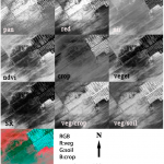
Saponaro M., Agapiou A., Hadjimitsis D.G., Tarantino E., Influence of spatial resolution for vegetation indices’ extraction using visible bands from unmanned aerial vehicles’ orthomosaics datasets, 2021, Remote Sensing, 13, 16, https://doi.org/10.3390/rs13163238
Agapiou A., Land cover mapping from colorized CORONA archived greyscale satellite data and feature extraction classification, 2021, Land, 10, 8, https://doi.org/10.3390/land10080771
Kassianidou V., Agapiou A., Manning S.W., Reconstructing an ancient mining landscape: A multidisciplinary approach to copper mining at Skouriotissa, Cyprus, 2021, Antiquity, 95, 382, https://doi.org/10.15184/aqy.2021.33
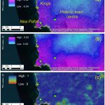
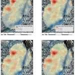
Cuca B., Agapiou A., Contribution of earth observation and geospatial information for urban planning of historic cities’ centres: The case study of Nicosia, Cyprus, 2021, Sustainability (Switzerland), 13, 13, https://doi.org/10.3390/su13137023
Agapiou A., Lysandrou V., Observing thermal conditions of historic buildings through earth observation data and big data engine, 2021, Sensors, 21, 13, https://doi.org/10.3390/s21134557
Agapiou A., Multi-temporal change detection analysis of vertical sprawl over Limassol city centre and amathus archaeological site in Cyprus during 2015–2020 using the sentinel-1 sensor and the google earth engine platform, 2021, Sensors, 21, 5, https://doi.org/10.3390/s21051884
Polykretis C., Alexakis D.D., Grillakis M.G., Agapiou A., Cuca B., Papadopoulos N., Sarris A., Assessment of water-induced soil erosion as a threat to cultural heritage sites: the case of Chania prefecture, Crete Island, Greece, 2021, Big Earth Data, , , https://doi.org/10.1080/20964471.2021.1923231
Evagorou E., Mettas C., Agapiou A., Themistocleous K., Papavasileiou S., Hadjimitsis D., Digital camera calibration for cultural heritage documentation: the case study of a mass digitization project of religious monuments in Cyprus, 2021, European Journal of Remote Sensing, 54, sup1, https://doi.org/10.1080/22797254.2020.1810131
Agapiou A., Damage proxy map of the beirut explosion on 4th of august 2020 as observed from the copernicus sensors, 2020, Sensors (Switzerland), 20, 21, https://doi.org/10.3390/s20216382
Agapiou A., Estimating proportion of vegetation cover at the vicinity of archaeological sites using sentinel-1 and-2 data, supplemented by crowdsourced OpenStreetMap geodata, 2020, Applied Sciences (Switzerland), 10, 14, https://doi.org/10.3390/app10144764
Agapiou A., Vegetation extraction using visible-bands from openly licensed unmanned aerial vehicle imagery, 2020, Drones, 4, 2, https://doi.org/10.3390/drones4020027
Agapiou A., Lysandrou V., Hadjimitsis D.G., Earth observation contribution to cultural heritage disaster risk management: Case study of eastern Mediterranean open air archaeological monuments and sites, 2020, Remote Sensing, 12, 8, https://doi.org/10.3390/RS12081330
Agapiou A., Lysandrou V., Hadjimitsis D.G., A European-scale investigation of soil erosion threat to subsurface archaeological remains, 2020, Remote Sensing, 12, 4, https://doi.org/10.3390/rs12040675
Agapiou A., Evaluation of Landsat 8 OLI/TIRS level-2 and sentinel 2 level-1C fusion techniques intended for image segmentation of archaeological landscapes and proxies, 2020, Remote Sensing, 12, 3, https://doi.org/10.3390/rs12030579
Lysandrou V., Agapiou A., The role of archival aerial photography in shaping our understanding of the funerary landscape of Hellenistic and Roman Cyprus, 2020, Open Archaeology, 6, 1, https://doi.org/10.1515/opar-2020-0117
Agapiou A., Lysandrou V., Detecting Displacements within Archaeological Sites in Cyprus after a 5.6 Magnitude Scale Earthquake Event through the Hybrid Pluggable Processing Pipeline (HyP3) Cloud-Based System and Sentinel-1 Interferometric Synthetic Aperture Radar (InSAR) Analysis, 2020, IEEE Journal of Selected Topics in Applied Earth Observations and Remote Sensing, 13, , https://doi.org/10.1109/JSTARS.2020.3028272
Agapiou A., Optimal spatial resolution for the detection and discrimination of archaeological proxies in areas with spectral heterogeneity, 2020, Remote Sensing, 12, 1, https://doi.org/10.3390/RS12010136
Agapiou A., Alexakis D.D., Hadjimitsis D.G., Potential of virtual earth observation constellations in archaeological research, 2019, Sensors (Switzerland), 19, 19, https://doi.org/10.3390/s19194066
Tzouvaras M., Kouhartsiouk D., Agapiou A., Danezis C., Hadjimitsis D.G., The use of Sentinel-1 synthetic aperture radar (SAR) images and open-source software for cultural heritage: An example from paphos area in Cyprus for mapping landscape changes after a 5.6 magnitude earthquake, 2019, Remote Sensing, 11, 15, https://doi.org/10.3390/rs11151766
Moutsiou T., Agapiou A., Least Cost Pathway Analysis of obsidian circulation in Early Holocene–Early Middle Holocene Cyprus, 2019, Journal of Archaeological Science: Reports, 26, , https://doi.org/10.1016/j.jasrep.2019.101881
Evagorou E., Mettas C., Agapiou A., Themistocleous K., Hadjimitsis D., Bathymetric maps from multi-temporal analysis of Sentinel-2 data: The case study of Limassol, Cyprus, 2019, Advances in Geosciences, 45, , https://doi.org/10.5194/adgeo-45-397-2019
Agapiou A., Sarris A., Working with Gaussian random noise for multi-sensor archaeological prospection: Fusion of ground penetrating Radar depth slices and ground spectral signatures from 0.00 m to 0.60 m below ground surface, 2019, Remote Sensing, 11, 16, https://doi.org/10.3390/rs11161895
Agapiou A., Enhancement of archaeological proxies at non-homogenous environments in Remotely Sensed Imagery, 2019, Sustainability (Switzerland), 11, 12, https://doi.org/10.3390/SU11123339
Cuca B., Agapiou A., Impact of land-use change and soil erosion on cultural landscapes: the case of cultural paths and sites in Paphos district, Cyprus, 2018, Applied Geomatics, 10, 4, https://doi.org/10.1007/s12518-018-0237-z
Agapiou A., Sarris A., Beyond GIS layering: Challenging the (Re)use and fusion of archaeological prospection data based on Bayesian Neural Networks (BNN), 2018, Remote Sensing, 10, 11, https://doi.org/10.3390/rs10111762
Lysandrou V., Agapiou A., Michaelides D., Papasavvas G., The Eastern necropolis of Nea Paphos: Overcoming challenges in a lost landscape, 2018, Journal of Archaeological Science: Reports, 19, , https://doi.org/10.1016/j.jasrep.2018.03.027
Cerra D., Agapiou A., Cavalli R.M., Sarris A., An objective assessment of hyperspectral indicators for the detection of buried archaeological relics, 2018, Remote Sensing, 10, 4, https://doi.org/10.3390/rs10040500
Agapiou A., Lysandrou V., Hadjimitsis D.G., Optical remote sensing potentials for looting detection, 2017, Geosciences (Switzerland), 7, 4, https://doi.org/10.3390/geosciences7040098
Kyriakides N., Lysandrou V., Agapiou A., Illampas R., Charalambous E., Correlating damage condition with historical seismic activity in underground sepulchral monuments of Cyprus, 2017, Journal of Archaeological Science: Reports, 14, , https://doi.org/10.1016/j.jasrep.2016.07.007
Lysandrou V., Cerra D., Agapiou A., Charalambous E., Hadjimitsis D.G., Towards a spectral library of Roman to Early Christian Cypriot floor mosaics, 2017, Journal of Archaeological Science: Reports, 14, , https://doi.org/10.1016/j.jasrep.2016.06.029
Agapiou A., Orthogonal equations for the detection of hidden archaeological remains de-mystified, 2017, Journal of Archaeological Science: Reports, 14, , https://doi.org/10.1016/j.jasrep.2016.07.004
Agapiou A., Lysandrou V., Sarris A., Papadopoulos N., Hadjimitsis D.G., Fusion of satellite multispectral images based on ground-penetrating radar (GPR) data for the investigation of buried concealed archaeological remains, 2017, Geosciences (Switzerland), 7, 2, https://doi.org/10.3390/geosciences7020040
Agapiou A., Lysandrou V., Hadjimitsis D.G., The Cyprus coastal heritage landscapes within Marine Spatial Planning process, 2017, Journal of Cultural Heritage, 23, , https://doi.org/10.1016/j.culher.2016.02.016
Agapiou A., Remote sensing heritage in a petabyte-scale: satellite data and heritage Earth Engine© applications, 2017, International Journal of Digital Earth, 10, 1, https://doi.org/10.1080/17538947.2016.1250829
Lysandrou V., Agapiou A., Cities of the dead: approaching the lost landscape of Hellenistic and Roman necropoleis of Cyprus, 2016, Archaeological and Anthropological Sciences, 8, 4, https://doi.org/10.1007/s12520-015-0267-y
Agapiou A., Papadopoulos N., Sarris A., Monitoring olive mills waste disposal areas in Crete using very high resolution satellite data, 2016, Egyptian Journal of Remote Sensing and Space Science, 19, 2, https://doi.org/10.1016/j.ejrs.2016.03.003
Franci F., Bitelli G., Mandanici E., Hadjimitsis D., Agapiou A., Satellite remote sensing and GIS-based multi-criteria analysis for flood hazard mapping, 2016, Natural Hazards, 83, , https://doi.org/10.1007/s11069-016-2504-9
Agapiou A., Alexakis D.D., Sarris A., Hadjimitsis D.G., Colour to Greyscale Pixels: Re-seeing Greyscale Archived Aerial Photographs and Declassified Satellite CORONA Images Based on Image Fusion Techniques, 2016, Archaeological Prospection, 23, 4, https://doi.org/10.1002/arp.1536
Agapiou A., Lysandrou V., Themistocleous K., Hadjimitsis D.G., Risk assessment of cultural heritage sites clusters using satellite imagery and GIS: the case study of Paphos District, Cyprus, 2016, Natural Hazards, 83, , https://doi.org/10.1007/s11069-016-2211-6
Agapiou A., Lysandrou V., Lasaponara R., Masini N., Hadjimitsis D.G., Study of the variations of archaeological marks at Neolithic site of Lucera, Italy using high-resolution multispectral datasets, 2016, Remote Sensing, 8, 9, https://doi.org/10.3390/rs8090723
Agapiou A., Alexakis D.D., Themistocleous K., Hadjimitsis D.G., Water leakage detection using remote sensing, field spectroscopy and GIS in semiarid areas of Cyprus, 2016, Urban Water Journal, 13, 3, https://doi.org/10.1080/1573062X.2014.975726
Hadjimitsis D., Agapiou A., Themistocleous K., Mettas C., Evagorou E., Soulis G., Xagoraris Z., Pilikou M., Aliouris K., Ioannou N., Maritime Spatial Planning in Cyprus, 2016, Open Geosciences, 8, 1, https://doi.org/10.1515/geo-2016-0061
Agapiou A., Papadopoulos N., Sarris A., Detection of olive oil mill waste (OOMW) disposal areas using high resolution GeoEye’s OrbView-3 and Google Earth images, 2016, Open Geosciences, 8, 1, https://doi.org/10.1515/geo-2016-0067
Beck J., Agapiou A., Emery P.B., Constantin D., Lysandrou V., Merminod B., Themistocleous K., Remote sensing of scoriae by hyperspectral imaging in Kataliondas Kourvellos (Cyprus): First test [Télédétection de scories par imagerie hyperspectrale à kataliondas kourvellos (chypre): Premiers essais], 2016, Antike Kunst, 59
Agapiou A., Lysandrou V., Remote sensing archaeology: Tracking and mapping evolution in European scientific literature from 1999 to 2015, 2015, Journal of Archaeological Science: Reports, 4, , https://doi.org/10.1016/j.jasrep.2015.09.010
Agapiou A., Lysandrou V., Alexakis D.D., Themistocleous K., Cuca B., Argyriou A., Sarris A., Hadjimitsis D.G., Cultural heritage management and monitoring using remote sensing data and GIS: The case study of Paphos area, Cyprus, 2015, Computers, Environment and Urban Systems, 54, , https://doi.org/10.1016/j.compenvurbsys.2015.09.003
Agapiou A., Alexakis D.D., Lysandrou V., Sarris A., Cuca B., Themistocleous K., Hadjimitsis D.G., Impact of urban sprawl to cultural heritage monuments: The case study of Paphos area in Cyprus, 2015, Journal of Cultural Heritage, 16, 5, https://doi.org/10.1016/j.culher.2014.12.006
Agapiou A., Alexakis D.D., Sarris A., Hadjimitsis D.G., Linear 3-D transformations of Landsat 5 TM satellite images for the enhancement of archaeological signatures during the phenological cycle of crops, 2015, International Journal of Remote Sensing, 36, 1, https://doi.org/10.1080/01431161.2014.990646
Agapiou A., Papadopoulos N., Sarris A., Discriminant analysis of olive oil mill wastes using spectroradiometers in the visible and near infrared part of the spectrum, 2015, European Journal of Remote Sensing, 48, , https://doi.org/10.5721/EuJRS20154844
Alexakis D.D., Grillakis M.G., Koutroulis A.G., Agapiou A., Themistocleous K., Tsanis I.K., Michaelides S., Pashiardis S., Demetriou C., Aristeidou K., Retalis A., Tymvios F., Hadjimitsis D.G., GIS and remote sensing techniques for the assessment of land use change impact on flood hydrology: The case study of Yialias basin in Cyprus, 2014, Natural Hazards and Earth System Sciences, 14, 2, https://doi.org/10.5194/nhess-14-413-2014
Cuca B., Agapiou A., Kkolos A., Hadjimitsis D., Integration of innovative surveying technologies for purposes of 3D documentation and valorisation of St. Herakleidios Monastery in Cyprus, 2014, Lecture Notes in Computer Science (including subseries Lecture Notes in Artificial Intelligence and Lecture Notes in Bioinformatics), 8740, , https://doi.org/10.1007/978-3-319-13695-0
Alexakis D.D., Agapiou A., Tzouvaras M., Themistocleous K., Neocleous K., Michaelides S., Hadjimitsis D.G., Integrated use of GIS and remote sensing for monitoring landslides in transportation pavements: The case study of Paphos area in Cyprus, 2014, Natural Hazards, 72, 1, https://doi.org/10.1007/s11069-013-0770-3
Agapiou A., Alexakis D.D., Hadjimitsis D.G., Spectral sensitivity of ALOS, ASTER, IKONOS, LANDSAT and SPOT satellite imagery intended for the detection of archaeological crop marks, 2014, International Journal of Digital Earth, 7, 5, https://doi.org/10.1080/17538947.2012.674159
Agapiou A., Alexakis D.D., Sarris A., Hadjimitsis D.G., Evaluating the potentials of Sentinel-2 for archaeological perspective, 2014, Remote Sensing, 6, 3, https://doi.org/10.3390/rs6032176
Agapiou A., Alexakis D.D., Sarris A., Hadjimitsis D.G., Orthogonal equations of multi-spectral satellite imagery for the identification of un-excavated archaeological sites, 2013, Remote Sensing, 5, 12, https://doi.org/10.3390/rs5126560
Alexakis D.D., Hadjimitsis D.G., Agapiou A., Integrated use of remote sensing, GIS and precipitation data for the assessment of soil erosion rate in the catchment area of “Yialias” in Cyprus, 2013, Atmospheric Research, 131, , https://doi.org/10.1016/j.atmosres.2013.02.013
Agapiou A., Hadjimitsis D.G., Alexakis D.D., Development of an image-based method for the detection of archaeological buried relics using multi-temporal satellite imagery, 2013, International Journal of Remote Sensing, 34, 16, https://doi.org/10.1080/01431161.2013.803630
Hadjimitsis D., Agapiou A., Alexakis D., Sarris A., Exploring natural and anthropogenic risk for cultural heritage in Cyprus using remote sensing and GIS, 2013, International Journal of Digital Earth, 6, 2, https://doi.org/10.1080/17538947.2011.602119
Agapiou A., Hadjimitsis D.G., Sarris A., Georgopoulos A., Alexakis D.D., Optimum temporal and spectral window for monitoring crop marks over archaeological remains in the Mediterranean region, 2013, Journal of Archaeological Science, 40, 3, https://doi.org/10.1016/j.jas.2012.https://doi.org/10.036
Sarris A., Papadopoulos N., Agapiou A., Salvi M.C., Hadjimitsis D.G., Parkinson W.A., Yerkes R.W., Gyucha A., Duffy P.R., Integration of geophysical surveys, ground hyperspectral measurements, aerial and satellite imagery for archaeological prospection of prehistoric sites: The case study of Vészto{doubleacute}-Mágor Tell, Hungary, 2013, Journal of Archaeological Science, 40, 3, https://doi.org/10.1016/j.jas.2012.11.001
Agapiou A., Hadjimitsis D.G., Alexakis D.D., Evaluation of broadband and narrowband vegetation indices for the identification of archaeological crop marks, 2012, Remote Sensing, 4, 12, https://doi.org/10.3390/rs4123892
Agapiou A., Hadjimitsis D., Alexakis D., Papadavid G., Examining the phenological cycle of barley (hordeum vulgare) using satellite and in situ spectroradiometer measurements for the detection of buried archaeological remains, 2012, GIScience and Remote Sensing, 49, 6, https://doi.org/10.2747/1548-1603.49.6.854
Alexakis D.D., Agapiou A., Hadjimitsis D.G., Retalis A., Optimizing statistical classification accuracy of satellite remotely sensed imagery for supporting fast flood hydrological analysis, 2012, Acta Geophysica, 60, 3, https://doi.org/10.2478/s11600-012-0025-9
Alexakis D.D., Hadjimitsis D.G., Agapiou A., Themistocleous K., Retalis A., Monitoring urban land cover using satellite remote sensing techniques and field spectroradiometric measurements: Case study of “Yialias” catchment area in Cyprus, 2012, Journal of Applied Remote Sensing, 6, 1, https://doi.org/10.1117/1.JRS.6.063603
Agapiou A., Hadjimitsis D.G., Alexakis D., Sarris A., Observatory validation of Neolithic tells (“Magoules” ) in the Thessalian plain, central Greece, using hyperspectral spectroradiometric data, 2012, Journal of Archaeological Science, 39, 5, https://doi.org/10.1016/j.jas.2012.01.001
Agapiou A., Hadjimitsis D.G., Papoutsa C., Alexakis D.D., Papadavid G., The Importance of accounting for atmospheric effects in the application of NDVI and interpretation of satellite imagery supporting archaeological research: The case studies of Palaepaphos and Nea Paphos sites in Cyprus, 2011, Remote Sensing, 3, 12, https://doi.org/10.3390/rs3122605
Agapiou A., Hadjimitsis D.G., Vegetation indices and field spectroradiometric measurements for validation of buried architectural remains: Verification under area surveyed with geophysical campaigns, 2011, Journal of Applied Remote Sensing, 5, 1, https://doi.org/10.1117/1.3645590
Hadjimitsis D.G., Papadavid G., Agapiou A., Themistocleous K., Hadjimitsis M.G., Retalis A., Michaelides S., Chrysoulakis N., Toulios L., I. Clayton C.R., Atmospheric correction for satellite remotely sensed data intended for agricultural applications: Impact on vegetation indices, 2010, Natural Hazards and Earth System Science, 10, 1, https://doi.org/10.5194/nhess-10-89-2010